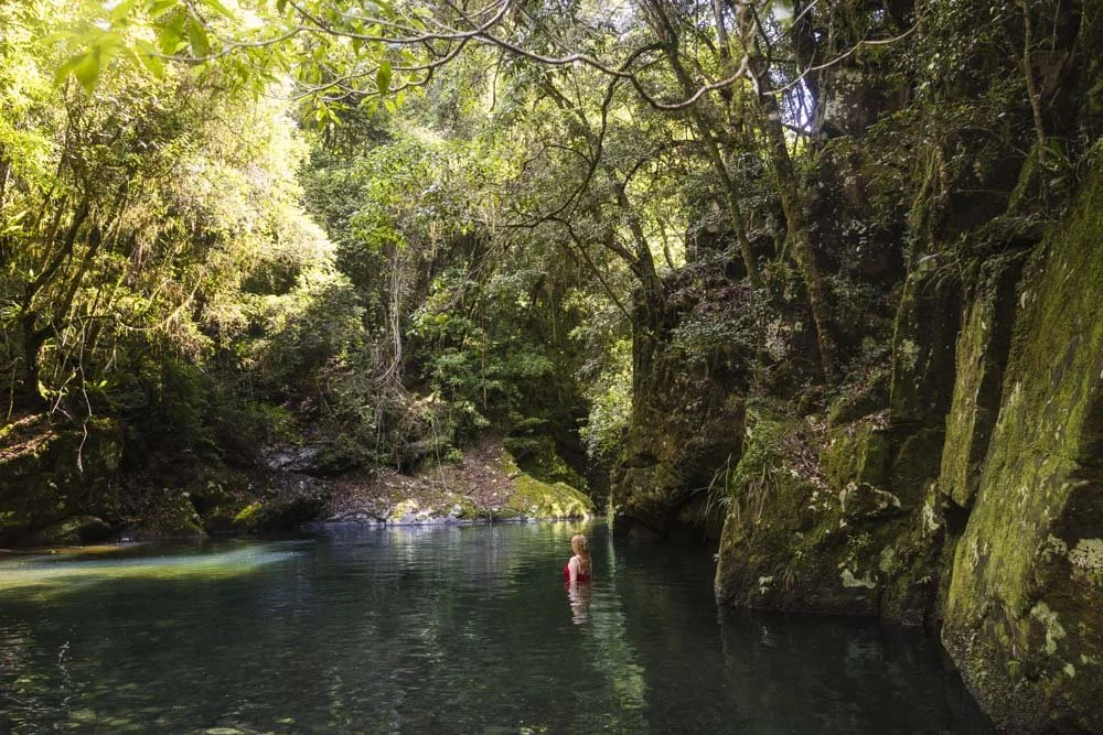
Potoroo Falls is a spectacular gorge waterfall with a picture perfect swimming hole at the base. What’s even more incredible is how remote and untouched it feels, despite the fact the walk to get there is so short. The falls are normally pretty tranquil, with clear green water, that is, unless you visit after heavy rain like we did.
If that’s the case it’s a lot more wild, but still a real beauty. Despite the conditions the water retained a lovely colour, which was actually blue, rather than the green I’d seen in pictures.
Here’s everything you need to know to visit the stunning Potoroo Falls.
The Potoroo Falls Walk
The stats
Distance: 1.2km return
Elevation gain: 0m, flat
Difficulty: Easy, but involves creek crossings
Summary: The walk to Potoroo Falls is entirely flat, but it does have some uneven terrain, including three creek crossings. The waterfall was pumping on our visit and despite this, the creek crossings were never above knee height.
I imagine they’re normally more like ankle height. The rocks underfoot on two of the crossings are slippery, but fine if you pick your way through carefully.
Starting the trail: through the rainforest
From the car park beside the picnic area (full details below), you’ll head slightly downhill to the creek crossing which leads to the start of the trail.
This creek crossing is bridged and the metal was nice and grippy, making it very easy to cross. Just 35m from the car park you’ll see a walking track sign and head right, into the rainforest on a narrow bush track.
The forest is gorgeous and the thick canopy and dense hanging vines offer plenty of shade on a sunny day.
Even though we were walking after plenty of rain, the path wasn’t muddy or slippery and surprisingly we didn’t encounter a single leech.
As you continue through the rainforest, you’ll catch some glimpses out to the creek, which shone a stunning shade of blue in the sunshine.
The forest is absolutely beautiful and though the upcoming creek crossings were a bit of a pain, it does keep the track feeling completely natural and adds to that remote feel.
The creek crossings
At the 200m mark you’ll reach the first unbridged creek crossing. This is the easiest crossing because it has a sandy bottom with very few rocks, so it’s not slippery.
It’s also quite shallow, for us it was only a little above ankle height.
I didn’t actually realise there were creek crossings on this walk and was really grateful that for the first time all summer I was wearing shorts on the trail and therefore didn’t soak my trousers!
Due to the fact you have to cross the creek three times each way (six times in total), you’re best off wearing shorts and - if you have them - walking sandals or water shoes to avoid having to keep taking your boots off.
After the creek crossing the trail continues through the forest and it’s flat, with decent conditions underfoot.
The next crossing comes 240m later and it’s a touch deeper - for us it was knee height. There are a few slippery rocks underfoot to be mindful of, but it’s not difficult if you watch your footing.
You then have a further 40m in the forest before needing to cross the creek for the third time. There is a lot of debris here, probably from all the floods, so it is the trickiest of the crossings.
The rocks are very slippery underfoot and there’s not much sand inbetween to help with footing. It’s not a long crossing by any means, but does require carefully stepping across the rocks, as the fine covering of mud makes them slick.
Once you’ve crossed the creek here you are just 60m away from the base of the falls. There is some debris to get through just before the falls, but it’s thin enough to step through without too much of an issue.
Swimming at Potoroo Falls
There is some tree fall sitting in front of the rocks that would have previously given an uninterrupted view of the falls. Unless that gets cleared, you will have to get into the pool, or walk across the rocks to the left to see the waterfall at its best.
You can see the falls from the first rocks you come to, but it’s between the debris, as seen in the photo below. If you’re here to swim, it doesn’t really matter though as the best views are from inside the pool.
Nevertheless, it’s an incredible spot and worth the visit whether you plan to swim or not, but I would make the effort to cross the rocks for that debris free view.
When it comes to swimming, access to the water is easy; the rocks inside the water are slippery, but most are avoidable as there are also sandy areas to take you through the shallow water into water that’s deep enough to swim.
The pool is huge and absolutely beautiful, with the waterfall and surrounding gorge walls making it very atmospheric. The current was powerful on our visit, but as mentioned, this is normally a tranquil spot.
Although large areas of the pool are rock and debris free, there is some significant tree fall and rocks inside the water. When water levels are lower and the water clearer, these will be much easier to see, so swimming-wise coming after less rain is preferable.
I still had a good swim, but did have to be very mindful of what lay beneath because the darker water colour did make debris harder to spot.
The left gorge wall didn’t have any debris at all on our visit, but the right side did, as did the area just before the water got fully deep.
Temperature-wise the water is quite cold, more so than I expected, but as we visited on a hot day it was perfect.
When you’re ready to leave the falls you simply retrace your steps back to the picnic area.
Keep them wild
Please remember to take all rubbish with you and keep these places wild and pristine - as with anywhere in the outdoors. It’s important to leave them exactly as you found them so they will remain beautiful for generations to come.
Litter tends to breed litter, so if you do spot any and are able to pick it up and dispose of it outside the national park, it will go a long way to keeping the area clean.
Getting to Potoroo Falls
Potoroo Falls is located in the Tapin Tops National Park. We visited as part of a trip to Barrington Tops and the journey time from Gloucester was about 1 hour 40 minutes. It’s closer to Taree at just an hour’s drive and Forster is around 1 hour 35 minutes away.
The best roads are from the eastern side, starting at Wherrol Flat. From Wherrol Flat, head north on Caparra Road before turning left onto Big Run Road (which becomes Dingo Tops Road). Turn left onto Rusty Road before turning right onto Potoroo Road which will take you down to the picnic area.
The last 19km of the road to the falls is gravel, with the final 2.5km being pretty steep. The road was in excellent condition (and generally should be as logging trucks use a large portion of it) and it’s designated as 2WD accessible when dry. When wet, the last 2.5km would be a problem for 2WD cars as it is relatively steep.
When you get to the car park you’ll find picnic benches and a long drop toilet.
This post may contain affiliate links, meaning at no additional cost to you, that we will earn a small commission if you click through and decide to make a purchase. This helps towards the costs of running our website. Thanks for your support.


