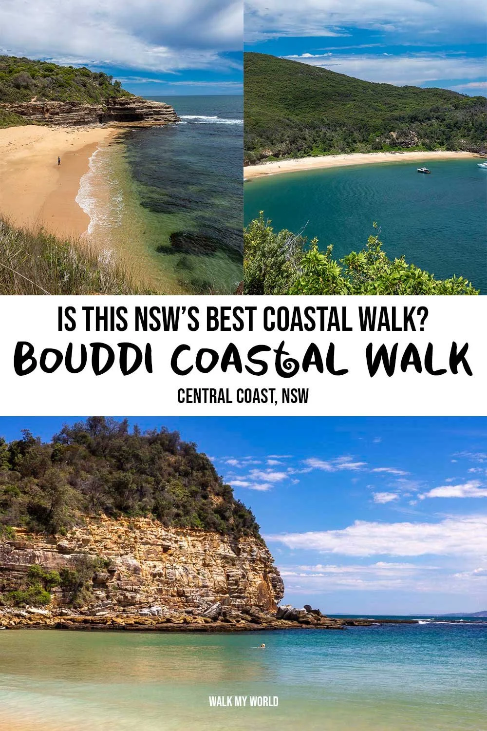
Known as one of the best coastal walks in NSW, the Bouddi Coastal Walk takes you past five stunning beaches, with glorious ocean views from the cliff tops along the way. Whilst the first and last beaches get busy, the ones in between are usually yours alone - or shared with just a handful of others if you’re visiting on a weekend or in the summer holidays.
Don’t forget your swimmers because one of the beaches has incredibly clear turquoise water and you won’t be able to resist a mid walk dip! It feels likes you’ve just landed in a tropical paradise.
However, the walk is not spectacular from start to finish, there are some sections which are a bit more mundane and we’ll outline those below so you can decide if you want to tackle the whole walk, or cherry pick the best bits!
Here’s everything you need to know about the Bouddi Coastal Walk.

The Bouddi Coastal Walk
The stats
Distance: 9.4km one way, beach to beach
Elevation gain: 438m
Difficulty: Moderate due to elevation gain, the track conditions are excellent
Trailhead: Putty Beach
Summary: The Bouddi Coastal Walk is a one-way track and unless you’re after a whole lot of exercise, you will probably want to arrange transportation one way (details below). There is a surprising amount of elevation gain across the track; the climbs are never sustained, but there are many of them!
There is more uphill climbing required than on many trails in the Blue Mountains which are known for their elevation gain.
The track condition is excellent, so there are no slippery bits or rough patches to worry about. Although there are some lovely shady sections, much of the walk is exposed, so you’ll really feel it on a hot or windy day.
The logistics of walking the track one way
Assuming you aren’t doing a car shuffle, you’re going to need to organise transport one way. Unlike the Patonga to Pearl Beach Track there are no buses servicing both ends of the trail. You will need to take a taxi or Uber one way.
We recommend parking your car at the free car park beside MacMasters Beach and taking a taxi or Uber to the trailhead at Putty Beach (a journey of approximately 9km/10 mins).
It’s much nicer to walk back to your car, than it is to finish a sweaty hike and then get into a complete stranger’s car!
We used Uber and got a ride accepted within minutes. The journey cost us $23. I’m not sure how this compares to a taxi as we just wanted to hit the trail and didn’t shop around.

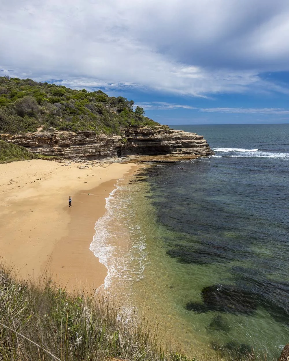
Starting the trail at Putty Beach: to the tessellated pavement
From the car park at Putty Beach you’ll head straight onto the beach, which is littered with driftwood.
It’s a popular swimming spot as the water is quite calm and there’s no walking involved, however, it’s not as beautiful as the beaches to come.

You’ll head left and spend the next 200m crossing the beach before taking the staircase uphill and onto the cliff tops.
It’s just a couple of staircases and then the path will flatten as you walk along the cliffs with sensational ocean views.

There are a couple of boardwalks and some walking along the rockshelves before you’ll come to one of the tracks most well known features, the tessellated pavement (665m from the car park).
This natural geological feature is a series of squares which sit together to form what looks like a set of tiles. It’s quite incredible to think it’s sculptured by mother nature!


To Bullimah Beach
From the tessellated pavement, you’ll continue on the flat path, hugging the cliff line for another 55m before you come to a junction.
Just a 135m detour each way will take you to Bullimah Beach. It’s mainly downhill, but on a well maintained wooden staircase.
The beach is small but very picturesque, with swirling sandstone walls at either end. The water is clear beside the beach, but there is a bit of weed just off shore (or there was the last few times we visited) so it’s not the best for swimming.
It is, however, always empty (even when we visited in the school summer holidays!) and a gorgeous place to sit and relax far from the crowds at Putty Beach.


It’s well worth popping down to enjoy the small secluded beach, or have a quick paddle in the shallow turquoise water.
To Gerrin Point Lookout and Maitland Bay
Once you get back to the junction you are just over 300m from Gerrin Point Lookout which offers sweeping ocean views and is perfect for whale watching (May to October).
You can even see the crescent shaped beach you’re heading to next in the distance.

The path to Gerrin Point Lookout is paved and a mix of flat and uphill. If you’re walking with kids, keep an eye out for two social trails leading left and right from the main track, roughly 150m on from the lookout.
Both lead to small kiddy sized caves and are only a 30 second detour each way!

The next part of the walk - all the way to Maitland Bay - is lovely and shady as you’re now in the forest. It’s a gorgeous stretch of bush and every bit as pretty as the coastal sections in my opinion.
There’s plenty of flat track, but also a fair number of steps, both up and downhill, along the way. At the 2.7km mark, or 1.4km from Gerrin Point Lookout, you’ll come to Marang Lookout on the right.
It’s just a few seconds detour and offers a mesmerising view of Maitland Bay on a sunny day.


Roughly 150m beyond the lookout you’ll come to the junction with the Maitland Bay Track and head right, towards the beach. There’s a little more downhill to go and you’ll arrive at the beach 250m later, or 3.1km into the walk.
Maitland Bay
If there’s a more spectacular beach on the Central Coast then we haven’t found it yet! Maitland Bay is everything you could wish for after walking 3km on a hot day.
A huge crescent of golden sand, with calm turquoise water, which was almost as clear as Jervis Bay! And to top it all off - even in the school summer holidays, there were only a handful of people there and a gigantic amount of space between them.
It really is a breathtaking beach, all 550m of it!

There is a track running down to the beach from the dedicated car park, so even though we have never seen many people here, it’s usually quietest at the furthest end, as you have to walk for over half a kilometre to get there!
Happily the Bouddi Coastal Walk continues at the far end anyway, so you’re not adding on any extra distance. As well as being very secluded, you’re also right by the steep headland on this side, which makes for a particularly special setting.

In terms of swimming the water is pretty calm, there are waves, but they are generally small and the water is very clear.
It’s not a patrolled beach, so always keep your wits about you, but I’ve always found it to be very leisurely.

If you’re not keen to do the full track, it’s worth noting by the time you have got to Maitland Bay you have done the best part of the walk, so it makes a good turn around point.


Continuing on and the Mount Bouddi detour
The coastal walk continues at the far end of the beach and you’ll see the little staircase leading uphill. Roughly 100m of steep stairs later the path will flatten and you’ll get a good view back over the beach.

There’s 50m of flat track to go before you reach Bouddi Lookout, which has two separate viewing areas, both great for whale watching.
You’ll then continue heading uphill for another 350m before you come to a signposted junction. Heading left will take you on a 1.7km return detour to the top of Mount Bouddi.
Now you may see the word ‘mount’ and assume that it will come with a lofty view from atop the summit…. I’m here to tell you that it doesn’t!


You will climb for 850m (more than the signpost suggests) and arrive to a forested ‘summit’ with no view to speak of.
The forest on the way is lovely, but if it’s views you are after, then you will be disappointed. We would only recommend the Mount Bouddi detour if you’re keen to lengthen the walk and get a few more steps in!


To Little Beach
Just 30m on from the junction you’ll come to Mullian Lookout on your right. It’s yet another great whale watching viewpoint!
From here you’ll head downhill on stairs for about 220m before immediately heading uphill again as you climb the next hump. And the next hump. And the next hump!
Yes, there’s still a lot more climbing to go after you leave Maitland Bay!

There are some little flat bits and of course the downhills too, but stairs are a common theme of the next section of track. Approximately 1.3km from Mullian Lookout you’ll reach my least favourite part of the walk: the fire trail.
Now it’s not unpleasant as such, but it’s mundane after all the great coastal views and forest and you’re still a fair way from Little Beach.

You’ll head gently uphill on the fire trail, which is surprisingly made of wood chippings, the first we’ve seen like it.
After 700m walking uphill on the fire trail you’ll come to a junction and continue straight, towards Little Beach. You’ll keep straight again 70m later at the fork.
The next 550m are still on fire trail, but now you’re heading gradually downhill. After this you’ll reach a signpost pointing left towards Little Beach and you’ll leave the fire trail behind and begin walking on a narrow sandy path, heading downhill through the bush.


This will later give way to a much steeper paved path through the forest, but the fact it’s paved means it’s easy to cover the steep ground.
You’ll head right at the signposted junction at the end of the steep path through the forest and you’re now just 250m from Little Beach campground.

Little Beach
The Little Beach campground is tiny, with just six sites, bookable on the National Parks Service website. There’s a long drop toilet and then six grassy sites, the best of which we think is number 5, as that is right beside the beach and has the best view!

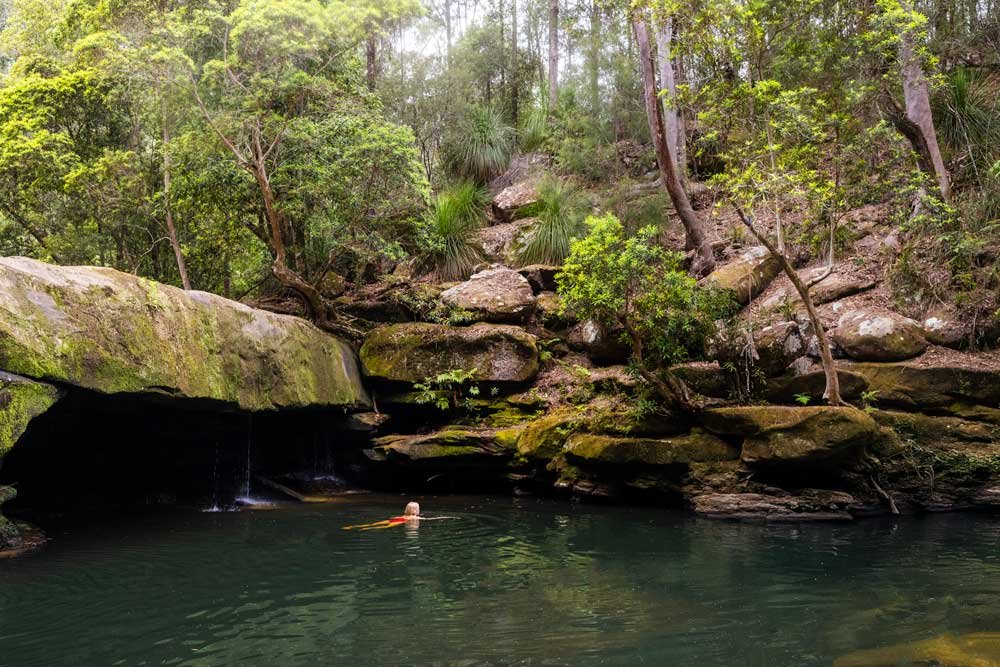
The beach is of course tiny, but it’s a pretty spot and there are lots of little rock pools at low tide (not swimmable). It’s also home to Swamp wallabies, although they were more shy here than at other campsites we’ve been to.

I imagine the campground is normally quiet, but it was fully booked on our most recent visit, so it did feel a little busy. Not the beach itself as no one was on it, but the area behind the beach.
Finishing the trail: to Macmasters Beach
From Little Beach the trail continues over the small wooden bridge and heads up, you guessed it, more stairs! You’ll pass another lookout after 100m which offers a view back over the beach and out to sea.

There’s another 300m of steep stairs before you hit the fire trail. However, it’s now mercifully flat or close to. You’ll reach a fork 450m later and head left when you will begin descending. You’ll reach a gate in front of the fire trail 200m later.
You are now at a road and could end the track here. Alternatively, if you want to complete the full walk you have another 800m to go. The first 300m are on a quiet residential street before you can turn right and follow the bushy track downhill for 300m.
There is a signpost at this junction, but it doesn’t tell you the coastal walk is to the right, so you’ll need to turn right when you get to the signpost shown in the photo below.
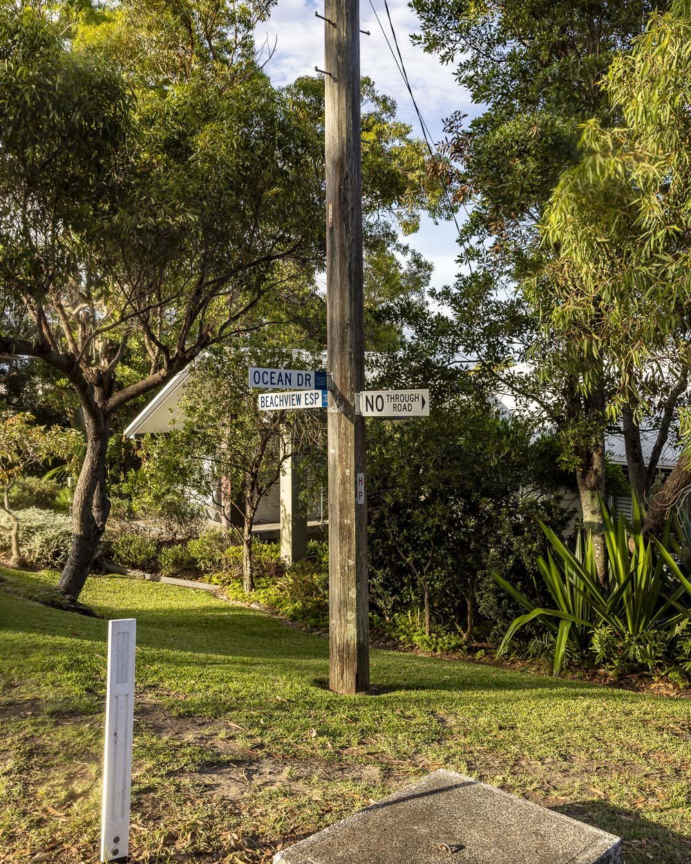
You’ll then pop briefly back onto a residential street before following the public pathway sign right, down the stairs. After 100m you’ll come to the road running alongside Macmasters Beach, inbetween the Surf Life Saving Club and the car park (just a minute from where you left your car).
Bouddi National Park car parking fee
If you park at MacMasters Beach, as described above, you won’t need to pay to park. If you park at Putty Beach you’ll need to pay the $8 daily rate. If you have an NSW Parks Pass you do not need to pay.
This post may contain affiliate links, meaning at no additional cost to you, that we will earn a small commission if you click through and decide to make a purchase. This helps towards the costs of running our website. Thanks for your support.